Summiting San Gorgonio
You know when you do something really difficult or traumatizing and you don’t really want to talk about it until a while after? Well, that’s sort of how I feel writing about summiting San Gorgonio (which was our training hike the weekend before Mount Whitney, along with San Jacinto). Don’t get me wrong, we had a GREAT time owning our victory at the top, but claiming the title of the highest peak in Southern California at 11,502 feet (the sign is actually 1 foot off lol), San Gorgonio is quite the beast.
This journey all started about 6 months ago when we met a friend while rock climbing in Malibu who mentioned that he had just received his permit to summit the “highest mountain in So Cal.” Of course we were intrigued and inspired, so naturally we decided that we HAD to do this too.
Upon filling out our overnight wilderness permit request, we had to decide on our top 3 choices for trailhead and camp site. We kept our fingers crossed for our #1 choices, the South Fork Trail and Dollar Lake, and luckily it worked. 2 weeks later, we received our approved permit request with our #1 choices in tact.
There are 8 different trails to choose from (click here for all trail distances and elevations), the shortest trail, which is what makes it the most popular, is Vivian Creek at 18.6 miles roundtrip. The longest trail, San Bernadino, is 17.3 miles… oneway! We chose the South Fork Trail because it is known to be the most beautiful trail, and at 21.4 miles roundtrip with 4,622′ elevation gain, it was also the perfect training choice for our Mount Whitney trip the very next weekend, which will be 22 miles roundtrip with 6,132′ elevation gain… bring it on.
Things to note:
This is an advanced hike, if you are an occasional hiker, wait until you would call yourself a skilled hiker before summiting this one.
Whether you want to do a day hike or an overnight hike, a wilderness permit is REQUIRED and they do check.
Apply for your wilderness permits, day and overnight, 3 months in advance; both are free.
If you decide to hike Gorgonio last minute and do not have a hiking permit, you can call the Mill Creek Ranger Station and ask if they have any passes left for the day in question. Each morning, they give away day-of passes, but if you want to hike Vivian Creek, which always sells out on weekends, they recommend getting to the station 30 minutes prior to opening because they only give away 3 day-hiking passes for Vivian. Be sure to check their hours, etc. as it varies on different days and the ranger station is closed on Tuesdays.
You must display an Adventure Pass in your car for each day you are parked. These can be purchased at the ranger station for $5 a pop.
By 9am we had our Adventure Passes on the dash, trail map in hand and were on our way to the trailhead, located just off Jenks Road, there’s a big “South Fork Trailhead” sign, can’t miss it. Once parked, we gathered our hiking poles, strapped on our 30-pound packs and off we went.
It was a steady 4-mile incline from the parking lot (6,900') to South Fork Meadows (8,400'), taking us 2 hours. Here the trail forks, hence South FORK Meadows, and depending on where your permit allows you to camp, you can either hike into Dry Lake (9,101'), which veers you 1.5 miles off course, or hike 2 miles along the trail to Dollar Lake (9,219), which is just .7 miles off course. Those next 2 miles towards Dollar Lake were extremely steep and difficult, partially due to the weight of our packs and partially due to our bodies trying to acclimate to the drastic 2,319' elevation change.
Note: Water is scarce on Gorgonio, besides the small stream at Horse Meadows near the beginning of the trail, when you don't usually need to refill, the ONLY "water" we found was halfway between South Fork Meadows (where the trail splits) and Dollar Lake and it was actually more of a mud pit. We would filter what we could, wait 10 minutes for it to fill again, and repeat. Pack in your water because dehydration can magnify the effects of altitude sickness. Click here for info on how to prevent altitude sickness.
Before arriving to Dollar Lake, we stopped to refuel and take a breather. I had never felt so exhausted by a hike and Drew was feeling quite the same.
We whipped out our mango, almond, cashew trail mix from Trader Joe's (omg, yum) and our trusty "Pita Pizza" ingredients that reminded us of our first camping experience together in college. Just think of healthier, adult version of Lunchables, haha!
We finally mustered up the courage to get back up, and by 2:45pm we reached Dollar Lake. The trail forks here as well and is a bit confusing. Down and to the left is Dollar Lake camp ground and up to the right is Dollar Lake Saddle, which is 5 miles to the peak.
We scoped out a good camping spot (1/4 mile away from the lake and trail) and set up our tent. We were debating whether we wanted to continue to summit, or wait to do so in the morning, but given the state of our energy levels and mood, we decided to take it easy for the rest of the day and save the summit for morning.
We don't usually build time in for relaxing on these kinds of trips, but let me tell you, it was really nice. We read, napped, ate, talked and had a nice dinner at sunset in the middle of Dollar Lake (photo below)... which was dry as a bone.
Sunday morning we were up at 7:45, we had slept a good 10 hours, obviously the elevation did not affect our ability to sleep. By 9:10 we were up and at it, feeling much stronger and very pleased with our choice to wait to summit. We left our bags and everything at the campsite so we could hike the remaining 5.7 uphill miles sans extra weight.
san gorgonio, south fork trail, san gorgonio summit, hiking san gorgonio, dollar lake
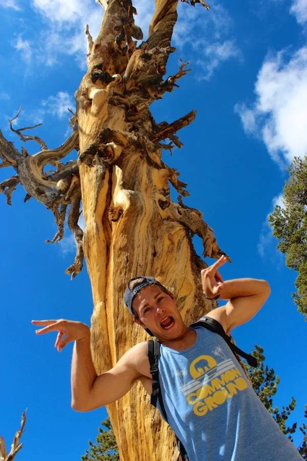
The trail was well marked, the weather was perfect, the trees (and Drew) were gnarly and just under 3 hours later, at noon, we finally reached the peak at 11,502 feet!
After enjoying the fresh summit air and sharing our trail mix with some chubby little chipmunks, we decided it was time to head back to camp, pick up our goods and make it towards home.
There is no doubt that the return trip, which was all downhill, was definitely easier, but still, not easy. A total of 17.9 miles later, we finally made it back to the car at 5:45pm.
Feeling accomplished, exhausted, thirsty and a little nauseous, we were happy to be heading home, but grateful for the incredible weekend we just spent in the mountains.


